Landscape Design Software for Simulating Ecosystems and Climate Impact
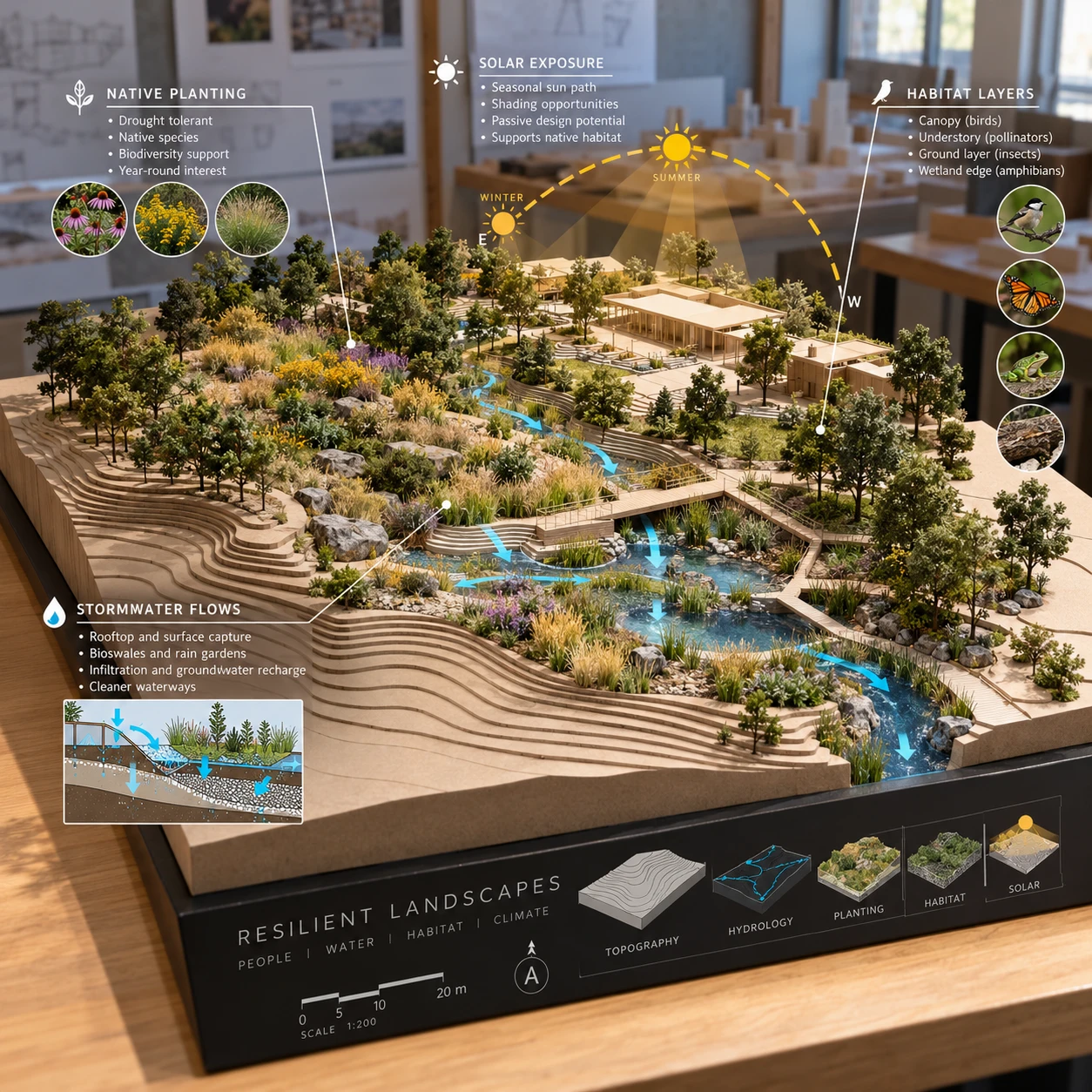
Landscape design software can help architecture and landscape studios test how a site may respond to planting, grading, water, and changing environmental conditions. Used well, it connects site analysis to design choices, making ecological performance easier to examine before a project is built.
These tools do not guarantee a particular ecological outcome. Their value lies in comparing alternatives, exposing assumptions, and giving designers a stronger basis for discussion with clients, engineers, ecologists, and other project partners.
Why simulate ecosystems and climate impact in landscape design?
Simulating ecosystems and climate impact helps designers compare how proposed landscape changes may affect a site’s water, shade, vegetation, and habitat. Early analysis can reveal design conflicts while there is still time to adjust the plan.
A baseline model gives a studio a shared picture of existing conditions: terrain, buildings, soils, drainage routes, tree cover, and areas exposed to sun or wind. Designers can then test alternatives against that baseline rather than relying on a single attractive visualization. For example, moving a tree grove may change summer shade, views, root-space requirements, and the amount of rain reaching a paved area.
This is especially useful during concept design, when grading, paths, building edges, and planting zones are still flexible. A comparison might ask whether a rain garden near a low point handles runoff more effectively than a series of smaller planted basins, or whether a denser canopy improves pedestrian comfort without blocking winter sun.
For a landscape architecture workflow, the aim is **better-informed decisions**, not a software-generated sustainability score. The trade-off is that more detailed models require more reliable site data and time to set up. A quick screening can guide early choices; a detailed assessment may need specialist input.
What environmental factors can landscape software model?
Landscape software can model or approximate solar exposure, shade, terrain-driven water movement, planting conditions, and selected habitat factors. The exact outputs depend on the tool, the data entered, and the level of analysis.
Solar exposure and shade tools use location, date, time, and 3D geometry to estimate where sunlight falls. This can help teams position trees, seating, paths, and outdoor work areas. Results depend on accurate building and tree geometry; a simplified canopy will not represent every gap or seasonal change.
Stormwater management features may use topography, surface types, and rainfall assumptions to trace runoff or estimate storage and infiltration. They can help compare permeable paving, swales, rain gardens, and detention areas. These estimates are not a substitute for drainage engineering, especially where soil infiltration, groundwater, or local code requirements control the design.
Vegetation and planting plans can represent mature height, canopy spread, spacing, and sometimes seasonal characteristics. This supports checks for shade, visibility, and spatial fit. Some tools also include soil, moisture, or hardiness information, but plant libraries vary in geographic relevance and detail.
Habitat and biodiversity analysis is more context-dependent. Designers may map habitat patches, connectivity, native planting areas, or features such as nesting and pollinator resources. Such layers can guide ecological questions, but they do not establish species presence or prove that biodiversity will increase. Field observation and ecological expertise remain essential.
Key tools and capabilities to look for
Useful landscape design software combines a clear site model with environmental analysis and a practical way to compare design scenarios. Choose capabilities that match the project’s decisions rather than selecting tools by feature count.
- 3D site modeling: Terrain, contours, buildings, walls, and tree geometry should be easy to import, build, and revise.
- Planting libraries: Look for editable plant attributes, mature dimensions, and regionally appropriate species data. Confirm whether the library distinguishes modeled assumptions from verified plant performance.
- Environmental analysis: Check which outputs are supported, such as sun and shade studies, runoff estimation, surface temperatures, or habitat mapping. Some analyses may require a separate application or plug-in.
- Scenario comparison: The software should make it possible to compare alternatives using consistent boundaries, inputs, and visual scales.
- Data exchange and documentation: GIS, CAD, BIM, and common file-format support can reduce rework. Exportable assumptions and analysis notes help reviewers understand how results were produced.
In a studio, usability matters as much as analytical depth. A specialist model may offer more detailed simulation but take longer to configure and interpret. A design-oriented platform may support faster iteration while providing only simplified environmental estimates. The right choice depends on project scale, staff skills, and whether the result is for early exploration or formal technical review.
A practical workflow for ecological design analysis
To integrate ecological analysis into a landscape project, establish a baseline, define a focused question, model alternatives with consistent assumptions, and review the results with the appropriate specialists. This sequence keeps simulation tied to design decisions.
- Assemble site information. Gather a survey or terrain model, property boundaries, buildings, known utilities, drainage information, soil data, existing vegetation, and local climate records where available. Record the source and date of each dataset.
- Map baseline conditions. Identify slopes, low points, existing shade, paved surfaces, vegetation, and known habitat features. Mark gaps in the information rather than silently filling them with assumptions.
- Set a decision question. Be specific: Which planting layout provides useful summer shade? Where could runoff be slowed? Does a proposed path interrupt a habitat connection?
- Create comparable alternatives. Keep the site boundary, weather inputs, analysis period, and calculation method consistent. Change the design variable being tested, such as canopy placement or the proportion of permeable surface.
- Review and refine. Compare outputs with site observations, project constraints, and advice from engineers or ecologists. Revise the design, then document what changed and why.
For instance, a studio assessing a courtyard could compare existing paving with a plan that adds tree canopy and planted drainage areas. The model may show likely shade patterns and indicate where runoff concentrates. A soil test and drainage review would still be needed before sizing infiltration features or promising a specific water outcome.
How to interpret simulation results responsibly
Simulation results are estimates based on inputs and assumptions, so designers should treat them as decision support rather than proof of future performance. Confidence is strongest when the data, method, and limits are visible.
Check the model’s **spatial resolution and time frame**. A shade study for one summer afternoon cannot represent a full year, and a runoff estimate based on a single rainfall event does not describe every storm. Similarly, a plant object in a 3D library may indicate mature canopy dimensions without modeling growth, mortality, pruning, or drought stress.
Use a simple confidence check for each output:
- Input quality: Is the terrain surveyed? Are soils and existing trees documented, or assumed?
- Method fit: Does the analysis address the actual design question and local conditions?
- Validation: Can observations, field measurements, or specialist review check the result?
A common mistake is treating a polished visualization as a verified forecast. The correction is to label estimates clearly and state the key assumptions in drawings or presentations. Another is comparing scenarios built with different weather inputs or levels of detail; that can make the apparent improvement meaningless. Keep the method consistent, and do not present modeled biodiversity or stormwater benefits as guaranteed outcomes.
For climate context, project teams can consult location-specific records and guidance from authoritative sources such as the NOAA National Centers for Environmental Information. Local standards and qualified professionals should guide engineering calculations and regulatory submissions.
Bringing ecosystem insights into a design proposal
To bring ecosystem insights into a design proposal, connect each analysis result to a visible design move, its expected benefit, and any remaining uncertainty. That makes environmental reasoning understandable without overstating what the model can prove.
A solar study might support a tree placement strategy for afternoon shade, while also showing where winter sun should remain available. A runoff analysis might inform grading and the location of rain gardens, permeable surfaces, or storage areas. A habitat review could lead to connected native planting zones, reduced disturbance, or a more diverse planting plan.
Present the analysis as a comparison, not a scorecard. Show the baseline and proposed option at the same scale, name the assumptions, and summarize relevant sustainability metrics in plain language. Depending on the project, useful measures could include estimated shaded area at a stated time, the area of permeable surface, or modeled runoff under a specified rainfall event. Avoid claiming carbon or biodiversity gains unless the method and evidence support those figures.
Clients often respond best when the environmental analysis is tied to experience and maintenance: cooler paths, manageable stormwater, suitable planting conditions, or places for habitat. Include practical constraints too. Native species may need establishment care; permeable materials can require maintenance; a dense planting scheme may conflict with sightlines or utilities. A credible proposal shows both the design opportunity and the work required to realize it.
Frequently asked questions
Landscape design software can help answer environmental questions, but the reliability of each answer depends on the model, project data, and validation. These common questions clarify what teams can reasonably expect.
What can landscape design software simulate?
Depending on the software, it can simulate or estimate sun and shade, terrain, runoff patterns, planting geometry, and selected habitat conditions. More specialized tools may support additional environmental analyses. Always check whether an output is a visualization, a screening estimate, or an engineering-grade calculation.
Can software predict a landscape’s climate impact?
Software can estimate parts of climate impact, such as shade patterns or runoff under defined assumptions, and help compare design scenarios. It cannot guarantee future ecological performance because weather, maintenance, soil conditions, plant survival, and human use can differ from the model.
What site data is needed for ecosystem modeling?
Common inputs include a site survey or terrain model, building geometry, existing vegetation, surface materials, soil and drainage information, and location-specific climate data. Habitat analysis may also require field observations and regional ecological information.
How should designers validate simulation results?
Check inputs against surveys and site visits, compare results with measurements or local records where possible, and ask relevant specialists to review technical analyses. Document assumptions, keep scenario methods consistent, and clearly distinguish modeled estimates from observed facts.